Resumen de las configuraciones RTK
RTK (cinemática en tiempo real) es una técnica de posicionamiento por satélite que mejora la exactitud de los receptores GNSS de unos pocos metros a unos pocos centímetros en tiempo real.
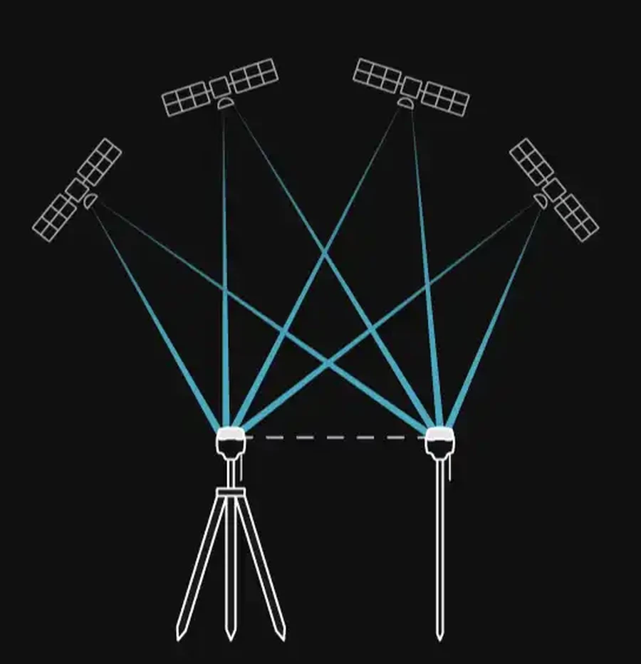
RTK funciona mediante el uso de dos receptores:
- una estación base fija
- un rover en movimiento
La estación base está situada en un lugar conocido y recibe señales de satélite de forma continua. A continuación, envía sus observaciones por satélite y los datos de posición al rover. Dado que ambos receptores observan los mismos satélites en condiciones prácticamente idénticas, el rover puede compensar los errores atmosféricos y los relacionados con los satélites y calcular su posición con una exactitud de centímetros en tiempo real.
Para obtener más información sobre el posicionamiento RTK, consulte nuestro artículo del blog:
Descubra cómo funciona la tecnología RTK y cómo permite un posicionamiento con una exactitud centimétrica.
Configuraciones RTK
Los receptores Reach admiten varias configuraciones RTK en función de su flota, la disponibilidad de internet, las condiciones ambientales y los requisitos del proyecto. Consulte la tabla siguiente para obtener más información sobre las posibles configuraciones:
| Flujo de trabajo | Cómo funciona | Se requiere conexión a internet | Se requiere una base local | Ideal para | Compatibilidad con productos de terceros |
|---|---|---|---|---|---|
| LoRa | La estación base y el rover se comunican a través de la radio LoRa de Emlid | No | Sí | Zonas abiertas sin cobertura móvil | Solo receptores Emlid |
| UHF | La base y el rover se comunican por radio UHF utilizando el protocolo Trimtalk 450S | No | Sí | Vegetación densa o entornos urbanos y configuraciones con flotas mixtas | Receptores compatibles con UHF que admiten el protocolo Trimtalk 450S |
| Emlid Corrections | Rover recibe correcciones RTK del servicio de Emlid a través de internet con una licencia de receptor activada. | Sí | No | Funcionamiento sin una estación base local en zonas con cobertura móvil fiable | No es relevante |
| Emlid Caster | La base y el rover se comunican a través del servicio gratuito Emlid Caster a través de internet | Sí | Sí | Emplazamientos con varios rovers que requieren control desde la base | Cualquier receptor compatible con NTRIP |
| Red RTK (NTRIP) | El rover se conecta a una red de correcciones de terceros a través de internet utilizando las credenciales NTRIP facilitadas por el proveedor de servicios. | Sí | No | Funcionamiento sin estación base local en zonas urbanas y semiurbanas con buena cobertura móvil | No es relevante |
Conceptos básicos sobre la configuración RTK
Antes de comenzar a realizar mediciones con RTK, debe tener en cuenta lo siguiente:
Visibilidad del satélite
En el caso de RTK, tanto la estación base como el rover necesitan una vista despejada del cielo. Cada receptor realiza el seguimiento de satélites de varias constelaciones. Cuantos más satélites se vean a la vez, más sólida y estable será la solución. Los obstáculos situados a más de 15 grados de elevación, como edificios, árboles y una densa copa de árboles, bloquean las señales y reducen el número de satélites utilizables.
Requisitos del enlace de comunicación
Línea de visión
Cuando se utiliza la comunicación por radio LoRa o UHF, la estación base y el rover necesitan una línea de visión despejada para garantizar un enlace de corrección estable. Los edificios, el terreno, la vegetación y otros obstáculos pueden reducir la calidad de la señal o interrumpir la comunicación.
A diferencia de la comunicación por radio, NTRIP no requiere una línea de visión directa entre la estación base y el rover.
Longitud de la línea base
La distancia entre la base y el rover, conocida como línea base, está limitada tanto para la comunicación por radio como para la comunicación a través de internet.
En el caso de la comunicación por radio, la línea base máxima admitida depende del modelo Reach, del tipo de radio, de los detalles de la configuración y del entorno circundante. Consulte la ficha técnica de su modelo Reach para conocer el rango compatible.
Cuando utiliza un servicio NTRIP o Emlid Caster, la estación base envía datos GNSS sin procesar al rover a través de internet utilizando el protocolo NTRIP. En esta configuración, la línea base no debería superar, por lo general, los 60 km. Sin embargo, el posicionamiento RTK parte de la base de que la estación base y el rover funcionan en condiciones atmosféricas similares. A medida que aumenta la distancia entre ellos, las diferencias atmosféricas pueden provocar errores y reducir la exactitud del posicionamiento. Para obtener los mejores resultados, mantenga la línea base entre la base y el rover lo más corta posible.
Interferencias electromagnéticas
Las interferencias electromagnéticas locales pueden afectar tanto a la recepción del GNSS como a las comunicaciones por radio. Para garantizar un funcionamiento fiable, mantenga la base y el rover alejados de fuentes de interferencias intensas, como líneas eléctricas, transmisores de radio, motores de gran potencia y equipos de comunicaciones.
Sistema de coordenadas
La estación base define el sistema de coordenadas para los datos de su levantamiento topográfico. Todas las mediciones del rover se calculan en ese mismo sistema de coordenadas.
Si la estación base está definida en un sistema de coordenadas distinto al requerido para su proyecto, cada punto medido se desplazará en el mismo desplazamiento horizontal y vertical. Por este motivo, el sistema de coordenadas configurado para el proyecto en Emlid Flow en el rover debe coincidir con el sistema de coordenadas utilizado por la base local o el servicio NTRIP.
Las discrepancias entre los sistemas de coordenadas son una de las causas más comunes de los errores en los levantamientos topográficos con GNSS. Antes de empezar a trabajar, compruebe que:
- las coordenadas de la base están definidas en el sistema de coordenadas correcto,
- el rover del proyecto utiliza el sistema de coordenadas correcto,
- y que todos los parámetros de localización o transformación se ajusten a los requisitos del proyecto.
Learn more about base setup and coordinate system configuration for your project in the following guides:
Comprobar estos ajustes antes de salir al campo es una de las formas más sencillas de evitar errores sistemáticos de posicionamiento.