Introduzione ai sistemi di coordinate
Panoramica
Per definire la posizione precisa degli oggetti rilevati nel mondo, è necessario impostare un
Coordinate system is a coordinate-based local, regional or global system used to locate geographical entities. A spatial reference system defines a specific map projection, as well as transformations between different spatial reference systems.
Quando si sceglie un
Coordinate system is a coordinate-based local, regional or global system used to locate geographical entities. A spatial reference system defines a specific map projection, as well as transformations between different spatial reference systems.
Coordinate system is a coordinate-based local, regional or global system used to locate geographical entities. A spatial reference system defines a specific map projection, as well as transformations between different spatial reference systems.
Rover is one of the two GNSS receivers that is used for collecting data in RTK or PPK scenarios. Rover is a moving unit: the surveyor uses rover to record the points, while rover receives the corrections from the static base.
Una mancata corrispondenza nell'impostazione del SC tra il
Rover is one of the two GNSS receivers that is used for collecting data in RTK or PPK scenarios. Rover is a moving unit: the surveyor uses rover to record the points, while rover receives the corrections from the static base.
Base is one of the receivers that act as a reference station in RTK or PPK scenarios. It is a static unit with the determined coordinates that sends corrections to the moving unit or rover. If the base is set over the known point, it provides absolute accuracy.
Configurazione
È possibile impostare il SC per il proprio progetto in diversi modi.
Scegli dalla libreria
Emlid Flow e Emlid Flow 360 contengono il registro verificato dei CS locali per Paesi specifici. Ogni
Coordinate system is a coordinate-based local, regional or global system used to locate geographical entities. A spatial reference system defines a specific map projection, as well as transformations between different spatial reference systems.
Rover is one of the two GNSS receivers that is used for collecting data in RTK or PPK scenarios. Rover is a moving unit: the surveyor uses rover to record the points, while rover receives the corrections from the static base.
The Networked Transport of RTCM via Internet Protocol or NTRIP network is an alternative source of corrections. NTRIP allows your rover to accept corrections over the Internet with no need for the second local receiver acting as a base. A reference station collects data, then sends it to NTRIP caster, where it is retransmitted through the Internet port to the client rover connected via a particular port and authorized.
In questo caso, le app applicano la
Grid distance is the distance measured on the projection flat plane.
Grid North azimuth is the angle measured clockwise between a line parallel to the central meridian, and the direction to a point of interest (a straight line between two points on the projection flat plane).
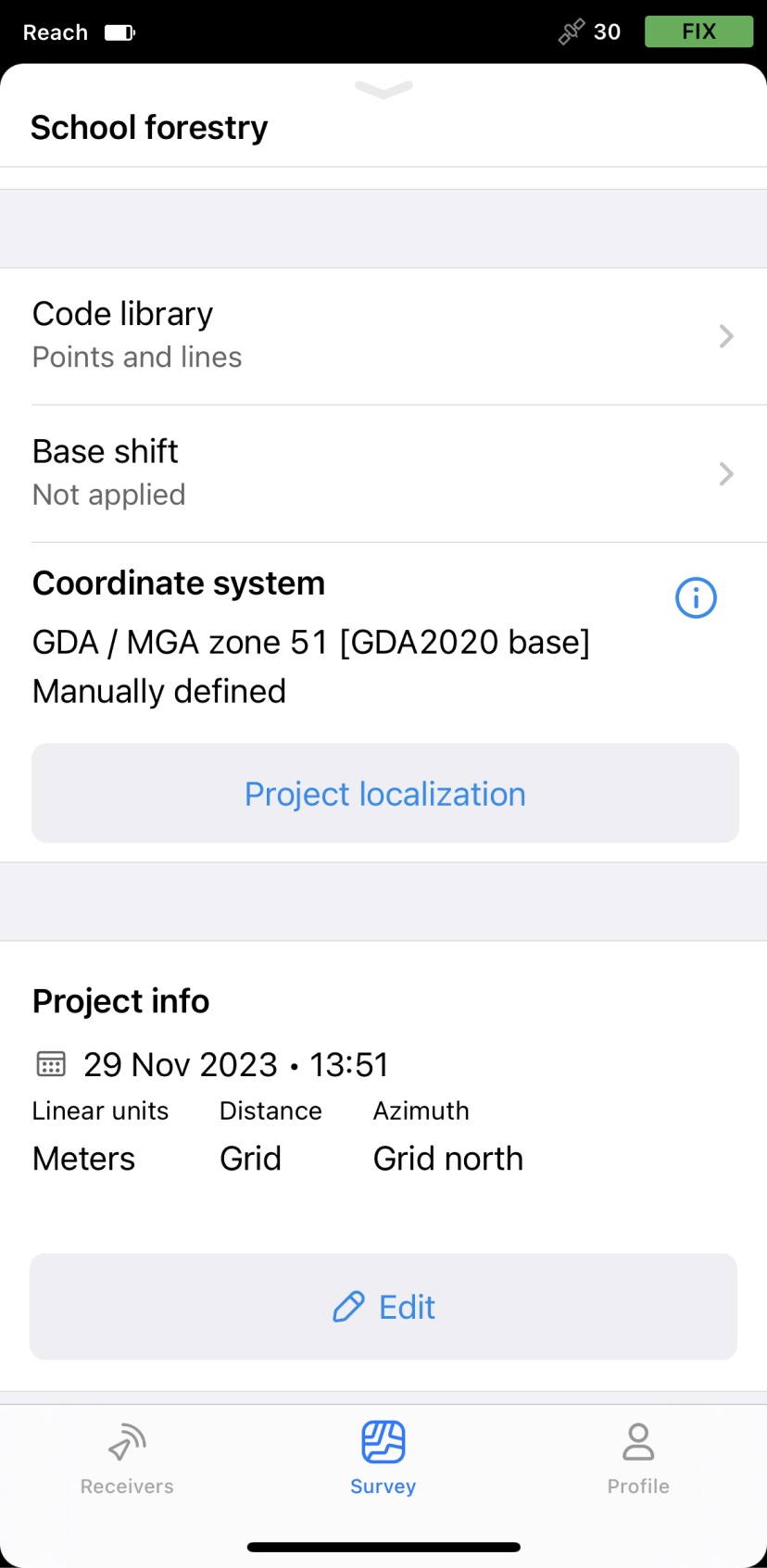
Di seguito è riportato un esempio di un
Coordinate system is a coordinate-based local, regional or global system used to locate geographical entities. A spatial reference system defines a specific map projection, as well as transformations between different spatial reference systems.
Rover is one of the two GNSS receivers that is used for collecting data in RTK or PPK scenarios. Rover is a moving unit: the surveyor uses rover to record the points, while rover receives the corrections from the static base.
The Networked Transport of RTCM via Internet Protocol or NTRIP network is an alternative source of corrections. NTRIP allows your rover to accept corrections over the Internet with no need for the second local receiver acting as a base. A reference station collects data, then sends it to NTRIP caster, where it is retransmitted through the Internet port to the client rover connected via a particular port and authorized.
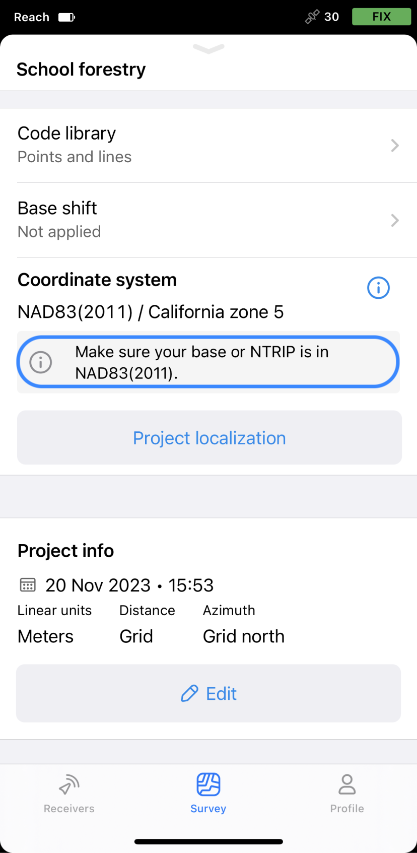
California zone 5 una proiezione.
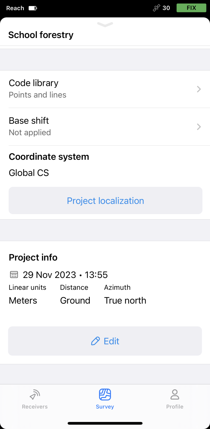
Applicare un SC globale
Questa opzione viene utilizzata per iniziare a usare l'app Emlid Flow e per effettuare test rapidi sul campo. Di conseguenza, si ottengono coordinate geografiche (latitudine, longitudine, altezza ellissoidica) nel datum della propria base.
In questo caso, le app applicano la
Ground distance is the distance measured on the actual surface of the Earth, taking the mean elevation of the measured points into account.
True North azimuth is the angle ranging from 0 to 360 degrees measured clockwise between True North and the direction to a point of interest.
Di seguito è riportato un esempio di utilizzo dell'opzione SC globale in Emlid Flow e Emlid Flow 360. Se si inseriscono le coordinate della base in NAD83(2011) nelle impostazioni della Base, si otterranno per default le coordinate NAD83(2011) con il
Rover is one of the two GNSS receivers that is used for collecting data in RTK or PPK scenarios. Rover is a moving unit: the surveyor uses rover to record the points, while rover receives the corrections from the static base.
Usare un SC personalizzato
Se si conoscono i parametri di proiezione e il sistema di coordinate locale richiesto non è supportato in Emlid Flow e Emlid Flow 360, è possibile aggiungere il proprio CS inserendo i seguenti parametri:
Poiché non tutti i gruppi di parametri sono necessari per la configurazione di un
Coordinate system is a coordinate-based local, regional or global system used to locate geographical entities. A spatial reference system defines a specific map projection, as well as transformations between different spatial reference systems.
- Ellissoide su cui è basato il datum
- Tipo di proiezione e relativi parametri
- Tipo di trasformazione e relativi parametri
- Modello geoide
In questo caso, le app applicano la
Grid distance is the distance measured on the projection flat plane.
Grid North azimuth is the angle measured clockwise between a line parallel to the central meridian, and the direction to a point of interest (a straight line between two points on the projection flat plane).
Di seguito è riportato l'esempio di un SC personalizzato impostato in Emlid Flow.