Visão geral das configurações RTK
RTK (Real-Time Kinematic) é uma técnica de posicionamento por satélite que aumenta a precisão dos receptores GNSS de alguns metros para alguns centímetros em tempo real.
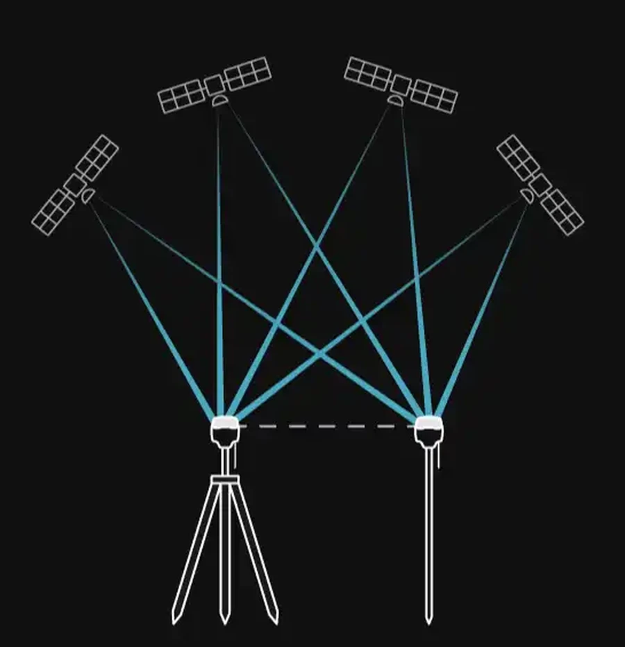
RTK funciona por meio de dois receptores:
- uma estação base fixa
- um rover em movimento
A estação base está localizada em um ponto conhecido e recebe sinais de satélite continuamente. Em seguida, ele envia suas observações de satélite e dados de localização ao rover. Como ambos os receptores observam os mesmos satélites em condições praticamente idênticas, o rover pode compensar os erros atmosféricos e relacionados aos satélites e calcular sua posição com exatidão na ordem de centímetros em tempo real.
Para saber mais sobre o posicionamento RTK, confira nosso artigo no blog:
Saiba como funciona o RTK e como ele proporciona um posicionamento com precisão de centímetros.
Configurações de RTK
Os receptores Reach oferecem suporte a várias configurações RTK, dependendo da sua frota, da disponibilidade de internet, das condições ambientais e dos requisitos do projeto. Saiba mais sobre as possíveis configurações na tabela abaixo:
| Fluxo de trabalho | Como funciona | É necessário ter acesso à Internet | É necessária uma base local | Ideal para | Compatibilidade com produtos de terceiros |
|---|---|---|---|---|---|
| LoRa | A base e o rover se comunicam por meio do rádio LoRa da Emlid | Não | Sim | Áreas abertas sem cobertura de celular | Apenas receptores Emlid |
| UHF | A base e o rover se comunicam por rádio UHF usando o protocolo Trimtalk 450S | Não | Sim | Vegetação densa ou ambientes urbanos e configurações de frotas mistas | Receptores compatíveis com UHF que suportam o protocolo Trimtalk 450S |
| Emlid Corrections | O Rover recebe correções RTK do serviço da Emlid pela internet com uma licença de receptor ativada | Sim | Não | Operação sem uma estação base local em áreas com cobertura de celular confiável | Não é relevante |
| Emlid Caster | A base e o rover se comunicam por meio do serviço gratuito Emlid Caster, pela internet | Sim | Sim | Locais com vários rovers que exigem controle da estação base | Qualquer receptor compatível com NTRIP |
| Rede RTK (NTRIP) | O Rover se conecta a uma rede de correção de terceiros pela internet usando as credenciais NTRIP fornecidas pelo provedor de serviços | Sim | Não | Operação sem estação base local em áreas urbanas e semiurbanas com boa cobertura de celular | Não é relevante |
Noções básicas sobre a configuração do RTK
Antes de iniciar o levantamento em RTK, é preciso levar em consideração o seguinte:
Visibilidade do satélite
No caso do RTK, tanto a estação base quanto o rover precisam ter uma visão desobstruída do céu. Cada receptor rastreia satélites em várias constelações. Quanto mais satélites estiverem visíveis ao mesmo tempo, mais forte e estável será a solução. Obstáculos com elevação superior a 15 graus, como prédios, árvores e copas densas, bloqueiam os sinais e reduzem o número de satélites utilizáveis.
Requisitos para o canal de comunicação
Linha de visão
Ao utilizar comunicação por rádio LoRa ou UHF, a estação base e o rover precisam de uma linha de visão desobstruída para garantir um canal de correção estável. Edifícios, relevo, vegetação e outros obstáculos podem reduzir a qualidade do sinal ou interromper a comunicação.
Ao contrário da comunicação por rádio, o NTRIP não exige linha de visão direta entre a estação base e o rover.
Comprimento da linha de base
A distância entre a base e o rover, conhecida como linha de base, é limitada tanto para a comunicação por rádio quanto para a comunicação pela internet.
Para a comunicação por rádio, a linha de base máxima suportada depende do modelo do Reach, do tipo de rádio, dos detalhes da configuração e do ambiente ao redor. Consulte a ficha técnica do seu modelo Reach para saber o alcance suportado.
Quando você utiliza um serviço NTRIP ou o Emlid Caster, a estação base envia dados GNSS brutos para o rover pela internet, utilizando o protocolo NTRIP. Nessa configuração, a linha de base geralmente não deve exceder 60 km. No entanto, o posicionamento RTK pressupõe que a estação base e o rover operem em condições atmosféricas semelhantes. À medida que a distância entre eles aumenta, as variações atmosféricas podem causar erros e reduzir a exatidão do posicionamento. Para obter melhores resultados, mantenha a linha de base entre a base e o rover a mais curta possível.
Interferência eletromagnética
A interferência eletromagnética local pode afetar tanto a recepção do GNSS quanto a comunicação por rádio. Para garantir um funcionamento confiável, mantenha a base e o rover longe de fontes de interferência intensa, como linhas de alta tensão, transmissores de rádio, motores de grande porte e equipamentos de comunicação.
Sistema de coordenadas
A estação base define o sistema de coordenadas para os dados do seu levantamento. Todas as medições do rover são calculadas nesse mesmo sistema de coordenadas.
Se a estação base estiver definida em um sistema de coordenadas diferente daquele exigido pelo seu projeto, cada ponto medido sofrerá um deslocamento horizontal e vertical igual. Por esse motivo, o sistema de coordenadas configurado para o projeto no Emlid Flow no rover deve corresponder ao sistema de coordenadas utilizado pela base local ou pelo serviço NTRIP.
As incompatibilidades entre sistemas de coordenadas são uma das causas mais comuns de erros em levantamentos topográficos por GNSS. Antes de iniciar o trabalho, verifique se:
- as coordenadas da base estão definidas no sistema de coordenadas correto,
- O projeto Rover utiliza o sistema de coordenadas correto,
- e que todos os parâmetros de localização ou transformação estejam de acordo com os requisitos do projeto.
Learn more about base setup and coordinate system configuration for your project in the following guides:
Verificar essas configurações antes de ir para o campo é uma das maneiras mais fáceis de evitar erros sistemáticos de posicionamento.